Frequently Asked Questions
1. How much does it cost?
For more details, check the Pricing and Process page.
Our services are divided in two parts: a Geological Study and a Geophysical (Electrical Resistivity Imaging - ERI) survey. The first part costs $500 and it is a pre-requisite for the second study, which costs $700. However, some properties in the USA are set on sedimentary geological formations, which requires the Schlumberger SEV survey, which is more more labor-intensive, and therefore requires the addition of $725 in extra fees. Contact us to learn if your property is or isn't over a sedimentary geological formation.
We also offer discounts for larger projects that require multiple studies.
2. What does it include?
Our work combines the analysis of existing geological data, geospatial imaging, historical well records, USGS ⇱ topographic maps, and local climate patterns to develop a comprehensive understanding of your property's water potential.
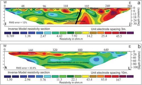
In practice, we produce two key reports. The first is a Geophysical Analysis of your property, which helps us identify areas with the highest potential for groundwater. Based on those findings, we then conduct a targeted Electrical Resistivity Tomography (ERT) test on the most promising location. The data collected is carefully processed and scientifically analyzed, resulting in the second and final report that includes detailed imaging and a clear assessment of your property's water potential.
Imaging example:

3. What is the process?
The best time to hire our services is before contacting a well driller—or even before purchasing a property.
However, if you've already bought the land or a well driller has submitted a permit request, we can still conduct our study. In some cases, this may require additional steps to amend the permit before drilling begins.
Once our contract is active, we start by remotely studying your property, which results in an initial report. We'll then review those findings with you to determine the ideal location for the second phase of the study, which is conducted on-site. During this visit, our team performs in-person tests and collects a wide range of geological and environmental data.
Our expert geologists thoroughly analyze all the data and prepare a detailed final report. This report identifies the exact location with the highest potential for a successful well, allowing you to confidently direct your preferred drilling company to drill in the optimal spot.
4. Is it possible to have negative results?
Yes. While we use the best available science and expertise, we cannot guarantee that your property contains water or that the water flow will meet your specific needs. Our goal is to identify the location with the highest potential for a successful well based on the existing geological conditions of your land.
5. Would I get a refund if the result is negative?
Unfortunatelly, no. The same process we use to locate the best place to drill is also used to determine if your property has low or even no potential for water. Potentially saving you thousands in future unfruitful wells.
6. Are there any guarantees?
We guarantee that we will conduct a professional geophysical and hydrogeophysical study of your property using industry-standard methods and equipment. However, the results we obtain will depend entirely on your property's natural geological conditions. These conditions can affect the test performance, including the depth the equipment can reach, the precision of the readings, and the overall margin of error. Our commitment is to deliver accurate, science-based data to help you make the most informed decision possible.
7. To which ground depth will the study go?
We guarantee a professional geophysical and hydrogeophysical study of your property using industry-standard tools and methods. However, the depth and accuracy of our analysis depend on the natural geological conditions of your site. In favorable conditions—which can also be influenced by recent weather—our equipment may allow us to study depths of up to 600 feet. Regardless of conditions, our goal is to provide you with the most accurate, science-based report to guide your well drilling decisions.
8. What size area does the study cover?
The standard geophysical study is designed for properties up to 50 acres in size (additional fees apply for larger properties). However, it's important to note that the Electrical Resistivity Tomography (ERT) test is not based on area coverage. Instead, it produces a vertical cross-sectional image of the subsurface along a single straight line. Our standard ERT setup typically spans approximately 1,181 linear feet, with the depth of penetration determined by the local geological conditions.
1. How much does it cost?
The standard Electrical Resistivity Tomography (ERT) test cost is $1200 (Twelve Hundred Dollars). Extra fees may apply for properties located outside our standard range of service.
1. How much does it cost?
The standard Electrical Resistivity Tomography (ERT) test cost is $1200 (Twelve Hundred Dollars). Extra fees may apply for properties located outside our range.
1. How much does it cost?
The standard Electrical Resistivity Tomography (ERT) test cost is $1200 (Twelve Hundred Dollars). Extra fees may apply for properties located outside our standard service range.
Important:
We do not drill water wells. We study the subsurface conditions of your property to best prepare well drillers and construction companies to make informed decisions.
✅ We are insured!